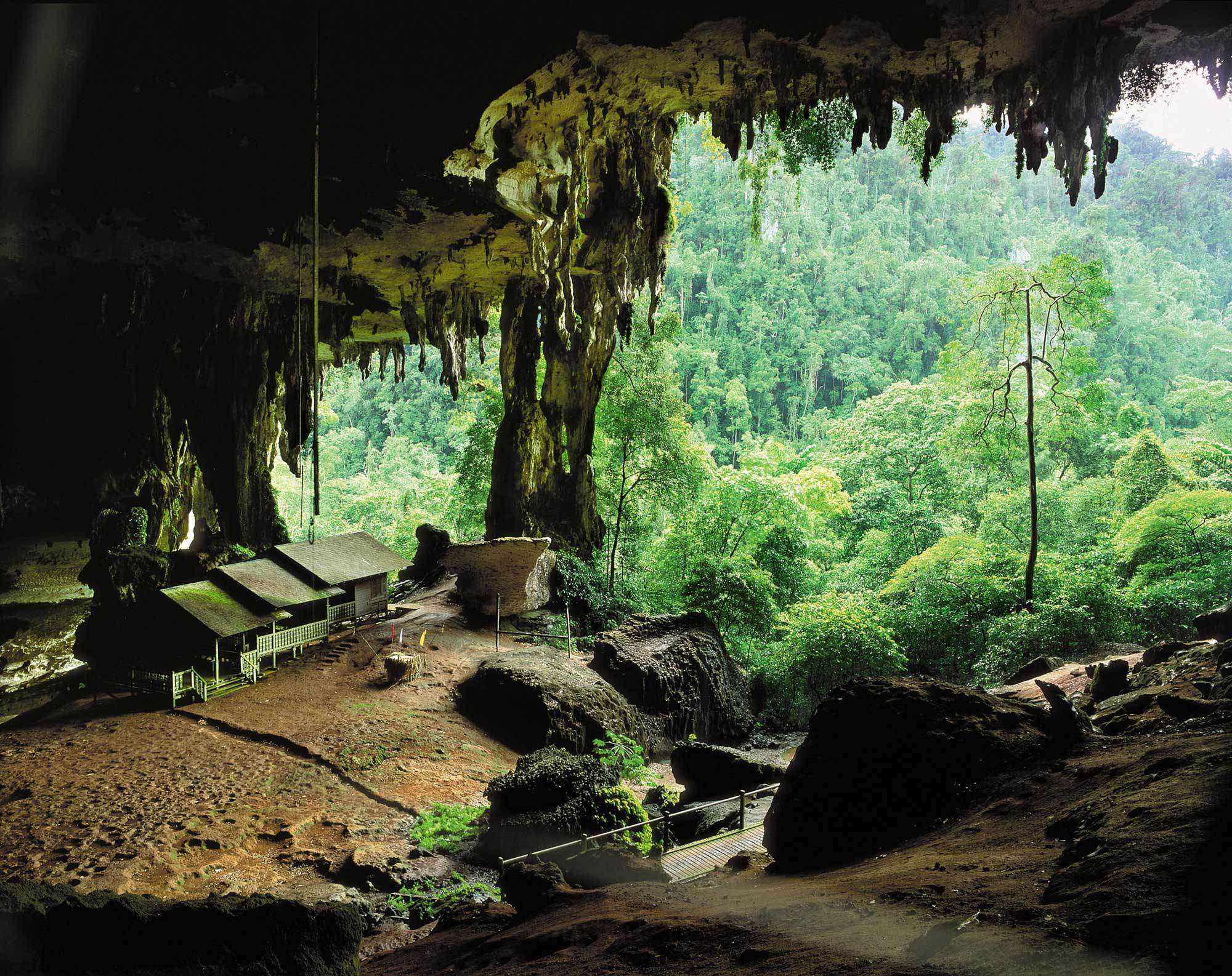
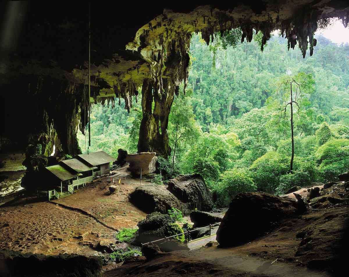
GUNUNG MULU NATIONAL PARK
The Gunung Mulu National Park is a national park in Miri Division, Sarawak, Malaysia. It is a UNESCO World Heritage Site that encompasses caves and karst formations in a mountainous equatorial rainforest setting. The park is famous for its caves and the expeditions that have been mounted to explore them and their surrounding rainforest, most notably the Royal Geographical Society Expedition of 1977–1978, which saw over 100 scientists in the field for 15 months. This initiated a series of over 20 expeditions now named the Mulu Caves Project. The national park is named after Mount Mulu, the second highest mountain in Sarawak.
-
Climate
The climate at Mulu national park are affected by northeast monsoon (December to March) and southwest monsoon (May to October). The amount of rainfall is high, which ranges from 4,000 millimetres (160 in) to 5,000 millimetres (200 in). In the lowlands, the temperature ranges from 23 °C (73 °F) to 26 °C (79 °F). At the summit of Mount Mulu, the temperature ranges from 14 °C (57 °F) to 18 °C (64 °F). The climate data shown is for the Mulu village near the airport and the entrance of the park. Interior and higher parts of the park have a cooler and wetter climate.
- Biodiversity
-
Fauna
There are 20,000 species of invertebrates, 81 species of mammals, 270 species of birds, 55 species of reptiles, 76 species of amphibians and 48 species of fish identified in the park area
-
Flora
Gunung Mulu National Park contains a large number of plant species. The park has 17 vegetation zones, with 3,500 species of vascular plants, and 1,500 species of flowering plants. There are 109 species in 20 genera of palms, over 1,700 mosses and liverworts, 8,000 species of fungi, and 442 species of spore-producing pteridophytes are recorded. Examples of vegetation zones found in the park are: peat swamp forest, heath, mixed dipterocarp forest, moss forest, and montane ecosystems. Lowland forests occupies 40% of the park area while montane forests occupies 20% of the park area.
-
Trekking routes
The national park has three climbing treks: The Pinnacles Summit Trek, The Headhunter's Trail, and Gunung Mulu Summit Trek.
-
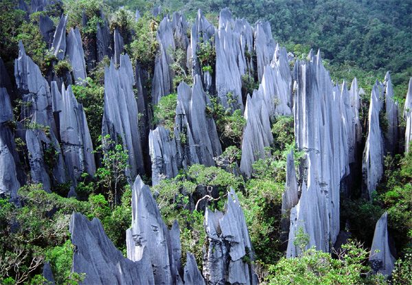
The Pinnacles Summit Trek
Pinnacles Summit Trek is a 3 days/2 nights trek leading to the view of the Gunung Mulu Pinnacles. The trek is usually starts with a one or two hours boat ride from Melinau river to Kuala Berar (Berar delta). The Base Camp 5 is a 7.8 km walk from Kuala Berar. Camp 5 is located near the Melinau Gorge which separates Mount Benarat from Mount Api. After Camp 5, there is a 1.2 km trek rising 1,200 metres; passing from dipterocarp forest to moss forest. The last section requires ropes and ladders to help with the climb
-
The Headhunter's Trail
The Headhunter's Trail is route taken to enter or leave the Gunung Mulu National Park. The trail follows the route taken by the Kayan from Melinau river to Melinau Gorge. The trail starts with a boat ride to Kuala Berar, then trek for two to three hours to reach Camp 5. From Camp 5, there is an 11.2 km trail leading to Kuala Terikan which could last for four to five hours. The climbers can either choose to stay at a ranger station Nanga Metawai (15 minutes from Kuala Terikan) or a longhouse named Rumah Bala Lesong (three to four hours by longboat). After that, a boat ride further downriver would reach Nanga Medamit where there is a road leading to Limbang.
-
The Gunung Mulu Summit trek
The Gunung Mulu Summit trek is the only trek to reach the summit of Mount Mulu. The summit is located at 24 km away from the park headquarters. The trek starts from the national park headquarters to reach Camp 3. It is a 12 km hike through the primary forests with an elevation of 1,200 metres. The mossy forest starts from Camp 3. It will be a few hours to climb to reach Camp 4. After Camp 4, there are a few vertical climbs which requires knotted ropes which eventually leads to the summit. Camp 1 is located along the descending trek from the summit of Mount Mulu. There is another 3-hour hike to reach the park headquarters from Camp 1.
-
Management and facilities
The Protected Areas and Biodiversity Conservation (PABC) Unit of the Sarawak Forestry Corporation is responsible for the management Totally Protected Areas (TPA) of Gunung Mulu National Park which covers 90% of the park area and is closed to the public. The remaining 10% of the park area is opened to visitors and is managed by Borsarmulu Park Management Sdn Bhd.
-
Transportation
BY AIR
Gunung Mulu is served by rural air service provider, Maswings. There are daily flights between Miri and Mulu and three weekly flights from Kuching and Kota Kinabalu -
By boat:
Get an early morning taxi from Miri to Kuala Baram
Take the lunchtime express boat between KB to Marudi
At Marudi, take a smaller boat to Long Terawan
At Long Terawan hire a small boat to the park -
Accomodation
Please contact the National Parks Booking office in Miri for reservations and the latest room rates.
-
Park Opening Hours:
8.00am to 5.00pm Monday – Sunday including Public Holidays
VISIT WEBSITE
ONLINE BOOKING
BAKO NATIONAL PARK
A National Park since 1957, Bako offers the perfect introduction to Sarawak’s forests and wildlife. The park covers the northern tip of the Muara Tebas peninsula, an area of 27 sq km. Despite its seemingly small size, Bako contains a wide range of vegetation – swamp forest, scrub-like padang vegetation, mangrove forest, dipterocarp forest, delicate cliff vegetation and more. In fact, at Bako it is possible to see almost every type of vegetation found in Borneo. Bako also contains a rich variety of wildlife and a coastline covered with small bays, coves and beaches. The park has a number of well-marked trails offering interesting walks ranging from short pleasant strolls to serious full-day hikes. Unlike some national parks, visitors to Bako are almost guaranteed to see wildlife. Long-tailed macaque monkeys and silver leaf monkeys are ever present, wild boar are often found rummaging around the park HQ, squirrels and monitor lizards are also common. There is every chance of seeing the rare and unusual proboscis monkeys on trails such as Telok Paku and Telok Delima, particularly if you go late afternoon. You are more likely to see wildlife if you quietly follow the trails and keep listening.
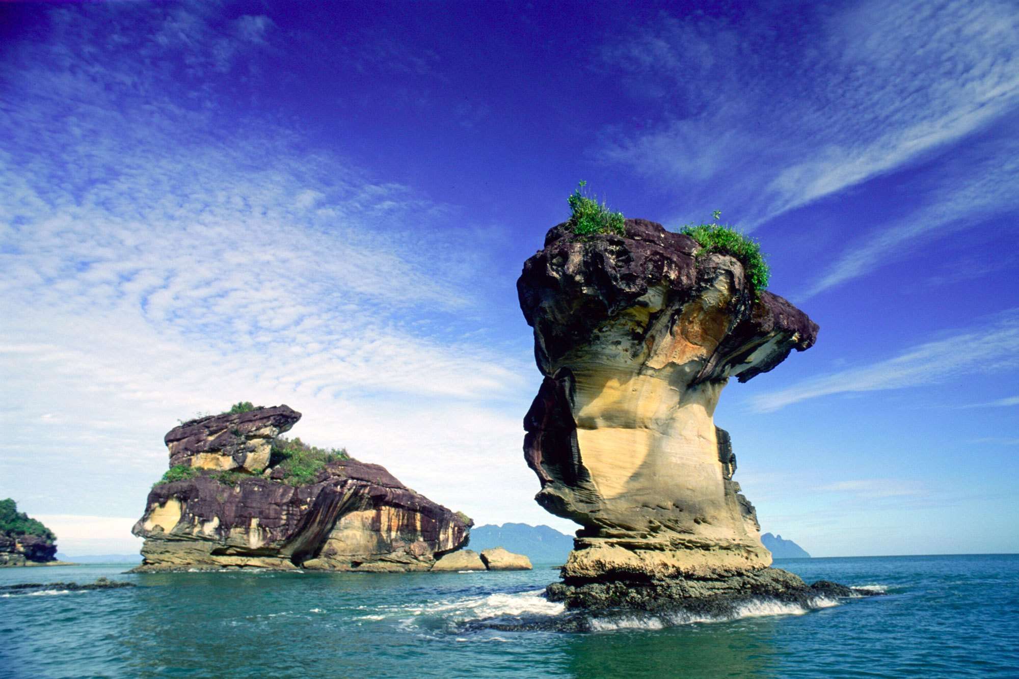
Bako also has some good white sand beaches that provide perfect resting spots in between jungle treks. Telok Pandan Kecil is perhaps Bako’s best beach. After an hour or so the Telok Pandan Kecil trail comes to a rocky headland. The view down to a beautiful secluded bay, and the thought of a swim in the cool waters, has a magical effect on tired calf muscles. The following 20 minute descent suddenly becomes more enjoyable. All of the beaches are bordered by limestone and sandstone cliffs, and the action of the sea has left some remarkable rock formations, such as the famous Sea Stack.
If you take a stroll at sunset on Telok Assam beach near the park HQ, you will see hundreds of swifts hovering around their nests at the rocks at the far end of the beach. Don’t leave the beach after the sun disappears behind Mount Santubong. Wait another 20 minutes as the sky’s colours often change dramatically, providing a colourful backdrop to the mountain.
-
Birding in Bako National Park
Highlight species ~ Rufous-backed Kingfisher, Ruddy Kingfisher, Stork-billed Kingfisher, Red-crowned Barbet, Brown Barbet, White-bellied Woodpecker, Black-&-Red Broadbill, Asian Fairy Bluebird, Mangrove Blue Flycatcher, Velvet-fronted Nuthatch, Abbott’s Babbler, White-chested Babbler, Sunda Scops Owl, Oriental Bay Owl, Buffy Fish Owl & etc.
-
Treks and Trails
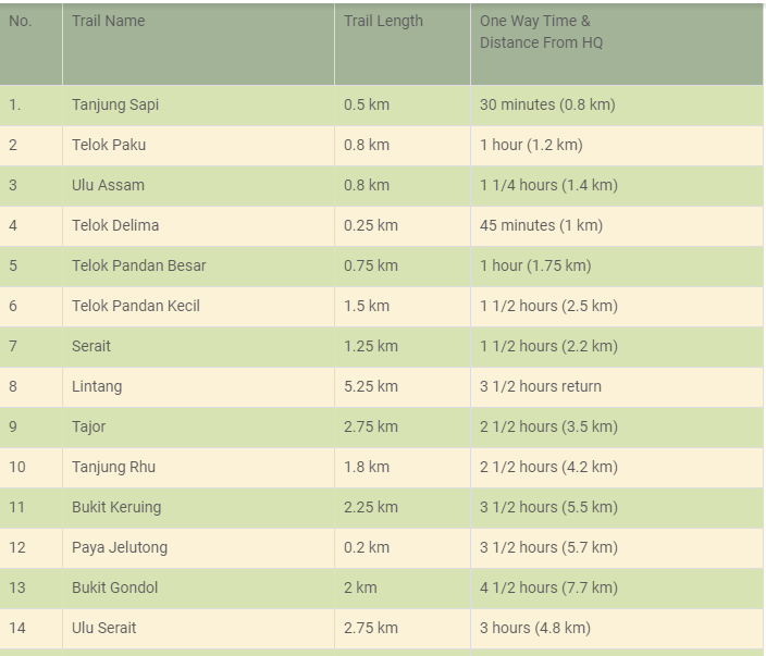
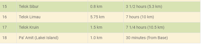
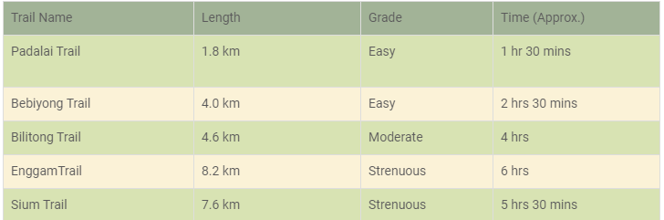
Bako’s extensive trail system is made up of 16 colour-coded jungle trails which offer a range of walking and hiking options. The fit and adventurous can opt for full-day jungle hikes or overnight camping expeditions, whilst those who prefer to take it easy can opt for a relaxing forest walk. The following table provides details of approximate trekking times and distances and the colour codes used in the park.
-
National Park Opening Hours:
8.00am to 5.00pm
Monday – Sunday including Public Holidays -
TRAVEL TIPS
Visitors are advised to bring along trekking attire and shoes, sunblock, swimming gear, insect repellent and basic first aid supplies.
If you a planning to stay overnight, it is advisable to do an online booking in advance. -
Getting There
1. Kuching - Bako Village (boat jetty): No. 1 (Rapid Kuching.) Bus Station near Open Air Market. Bus Fare RM3.50 each way. Depart every hour 7am - 6pm Return every hour 8am - 5pm OR RM60 each way by Taxi OR RM5 each way by mini bus [Van] Station near Open Air Market. Depart when there are enough passengers.
2. Bako Village - Bako National Park: RM30 p/person-each way. -
Additional Information
A bus ride from Kuching to Bako Market takes about 45-60 minutes (red public bus number 1, originating from the wet market beside the Electra building, which will also pick up passengers from the burger stand opposite Riverside Majestic Hotel, Kuching and costs RM3.50 each way. Buses leave to/from Bako about once every hour starting from about 7am from Kuching and finishing about 6pm from Bako, A minivan can be chartered for around RM30, and seats 5-7 people. They can reach Bako in half the time of the public bus, stationed near the Open Air Market, depart when there are enough passengers. When you arrive at the Bako Market right in front of the jetty/visitor center, register, purchase your entrance ticket and buy your boat ticket. This 20-minute boat ride will lead you to the Bako National Park Headquarters. Enquire at the registration counter for details. There will be an additional boat fee if you wish to visit the Sea Stack or Bako's remoter beaches. The boat ride is an adventure in itself, with the skilled and experienced boatmen riding the surf at high speed, to the delight of most visitors.
-
Bako Boat Service Counter
(Monday-Sunday, 9.00am to 3.00pm)
VISIT WEBSITE
NIAH NATIONAL PARK
Niah National Park includes palaeolithic & neolithic burial sites, ancient cave paintings and the spectacular cave mouth of the Great Cave, one of the world’s largest cave entrances. The park was gazetted in 1974 and covers 3,183 hectares of rainforest and limestone hills. Whilst Mulu National Park’s cave system is more famous and receives more visitors, Niah Caves has much to offer and is an interesting day trip from Miri. The Great Cave at Niah sheltered human life some 40,000 years ago and this led to a reappraisal of the theories of human distribution on earth. What is even more amazing is there is evidence of continuous humans habitation in this cave until very recently. The park has a visitor information centre, chalet accommodation and a network of plankwalks that allow visitors to explore the forest and enter the caves.
-
The Great Cave
The Great Cave at Niah is truly spectacular both in terms of its enormous size and historical significance. The mouth of the Great Cave is 60 metres high and 250 wide and its floor area covers 10.5 hectares. The cave is accessed from the park HQ by a 3.1 km jungle trail and plankwalk. Archaeological excavations can be see on the left of cave mouth. From the cave mouth a passage leads to a large chamber at the back known as the Padang. Here rock formations are illuminated by shafts of light that the shine though holes in the cave roof. Beyond the Padang is a dark passage called Moon Cave (Gan Kira). The Great Cave has a long history of human settlement. In 1950s and 1960s Niah was the focus of intense archaeological research with excavations led by Tom Harrisson, the curator of the Sarawak Museum, and his wife Barbara. The Harrissons and their team found evidence of long term human occupation and burial. Earthenware, ornaments, bone tools and food remains were found in the caves. Their most notable find was a human skull. The skull was found in 1958 in the West Mouth of the Great Cave. The skull belonged to an adult female. Radiocarbon dating of the charcoal found at the same level of the dig, suggested the skull was 40,000 years old. This made it the oldest modern human fossil known at that time.
-
The Painted Cave
The Painted Cave is a smaller cave at Niah where archaeologists found burial grounds and paintings of red human figures on the cave walls. Boat shaped coffins or ‘death ships’ were also found at the Painted Cave. The burial sites at the Painted Cave are far more recent than those found at the Great Cave.
-
Accommodation
The Forest Lodge Type 1 (1 king bed, air-con, attached bathroom and toilet, living room and fridge) is RM 300.
A room in the Forest Lodge Type 2 (2 single beds, air-con, attached bathroom and toilet) is RM 250. If you take both rooms in the lodge it costs RM 500.
A room in the Forest Lodge Type 4 (4 single beds, air-con, attached bathroom and toilet) is RM 150. If you take both rooms the price is RM 225.
A room in a Forest Lodge Type 5 (4 single beds, fan and attached bathroom & toilet) is RM 100 per night. If you take both rooms the price is RM 150.
A bed in a 4-person hostel room is RM 15. If you take the whole hostel room the price is RM 40.
There is a campsite with space for 25 tents. Price is RM 5 per person.
You can book rooms at Niah on the Sarawak e-booking website. -
Entrance Fees
The entrance fee for foreigners is RM 20 (adult) and RM 7 (child, 7-18 years). The price for Malaysians is RM 10 (adult) and RM 3 (child, 7-18 years). Malaysians may be asked to show their IC card as proof of citizenship. Children 6 years and below are free.
-
Getting To Niah National Park
Niah National Park is located on the Sungai Niah, about 3 km from the town of Batu Niah. The park is accessible from both Miri and Bintulu. It is 80 km from Miri via the coastal road and 110 km from Miri on the main Miri-Bintulu road. Niah is located approx. 115 km from Bintulu.
From the Pujut Corner Bus Terminal in Miri you can take any bus going to Bintulu, Sibu or Kuching and ask the driver to be dropped off at the Niah Rest Stop. Bus fare is RM 10-15 depending on the type of bus and the operator. From Bintulu take any bus to Miri and get off at Niah. The fare from Bintulu is RM 15-20.
From the Niah Rest Area take a private taxi to the park HQ (RM 30-50). Alternatively, try to see if you can get a Grab car.
A taxi from Miri to Niah National Park is around RM 160 one-way. With Grab the fare is RM 100-120. -
Operating hours
Saturday-Tuesday 8:30am to 1pm
Wednesday-Friday 8am to 1pm
ADDRESS:
98200 Miri, Sarawak, Malaysia
VISIT WEBSITE
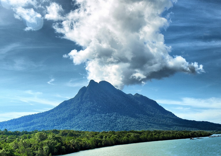
MOUNT SANTUBONG
Santubong National Park is a great place for a day visit. Santubong is located on the Damai Peninsula, 35km north of Kuching. Seen from sea level, it’s irregular rainforest-covered peaks rise steeply to 810m, forming a catchment for a variety of wildlife. Gunung Santubong provides a spectacular backdrop to hotel resorts, local fishing villages, and the Sarawak Cultural Village. The main popular activities here are hiking to Santubong Summit and swimming at the Waterfall. Its striking peak is visible from Kuching on most days. During your visit, make sure you ask a local about the legend of the Santubong princess!
-
Climbing Mount Santubong
Mount Santubong has 4 trail options that differ by starting at various entry points, some of which require an admission fee. However, all 4 trails merge at the first View Point. There’s no permit required to climb Santubong and the entire hike shouldn’t take more than 8 hours in total. The climb can be challenging with steep vertical climbs across rope ladders and dense jungle using tree roots as stepping stones.
-
Accomodation
No overnight accommodation available in Santubong National Park.
-
Trail options
There are 4 different entry points to start the trek to the summit of Mount Santubong but all merge at about 2/3rd of the trail at View Point 1, so essentially what you get are different views of the forest and little difference in the trek time or difficulty, whichever trail you choose. As all the trails merge after a point, there is really no distinction between each and your choice of trail wholly depends on which parts of the jungle you wish to see and whether you want to make use of the small differences in time and distance. Upto the intersection of the trails, the terrain is not too steep and involves some scenic stretches with river crossings and a waterfall. From there onward there are several rock faces and tall boulders to deal with, which you will need to surmount with the help of ropes and ladders.Most visitors opt to start at one point and descend through one of the others so that you get a greater experience of the forest with its many little surprises in the form of brooks and waterfalls.
-
FACILITIES
Guides and portersGuides are not required
Trail facilities
Porters are not requiredTrail head - Registration kiosk
Food & water
Trail head - Toilets / Bathrooms
Trail - Rest stop shelters, such as huts, pavilions, etc.
Trail - Built-in hand-holds, guide-ropes, and hazard markings at technically difficult sections.
Trail - Publicly displayed trail mapsTrail head - Food
Trail head - Potable water
Trail - Food & potable water only available from guide / porters -
SAFETY & ACCESSIBILITY
WeatherDaytime temperatures hover in the range of 27 to 30 degrees Celsius for most of the year. The dry season between June and August is the best season to climb Mount Santubong. Try to start the climb as early as you can in the morning so that you can get back to the base before the afternoon thunderstorms that tend to happen throughout the year. Check the local weather conditions before embarking on the trek and be sufficiently prepared with raincoats or ponchos as well as shoes with good grip for the slippery surfaces.
Climbing safetySlips and falls: Though not a very tall mountain, Mount Santubong is not exactly a beginner’s climb with its sheer rock surfaces that require you to climb over rope ladders. There is always the danger of slipping and falling or sustaining minor injuries on this trail. Be sure to have some level of training before embarking on the climb and carry basic medical supplies.
Permits, Fees, and RegulationsYou don’t need a permit for the trek but you need to register yourself in the visitor’s log at the entry points to the trail, where you’ll be given a registration slip.
Emergency contactsPolice & Ambulance: 999,Fire: 994
-
Getting there and away
Kuching International Airport is the entry point to the state of Sarawak in Malaysia and is about 11km from Kuching City center. From Kuching City, it is easy to get a cab or a minivan or bus to Santubong. Some hotels operate tour buses too. It is only 45 minutes to Santubong from Kuching City.
-
Money Matters
Leaving your car at the Green Paradise Seafood Restaurant will cost you a car park fee of RM5 and there’s an RM8 admission fee from this entry point per person.
-
Tips for amateur climbers
Though the height of the mountain is not intimidating this is not exactly a beginner’s trek because of the steep boulders that require you to have at least a basic exposure to rock climbing. If you would rather not make the entire trek, opt for the jungle trek circuit that will give you a nice experience of the rainforest and waterfall in the area.
In earlier 2019, a climber from Cyprus was lost for a couple of days on Santubong and had to be rescued. So please stick to the trail. -
Park Opening Hours:
8.00am to 5.00pm Monday – Sunday including Public Holidays
VISIT WEBSITE
ONLINE BOOKING
KUBAH NATIONAL PARK
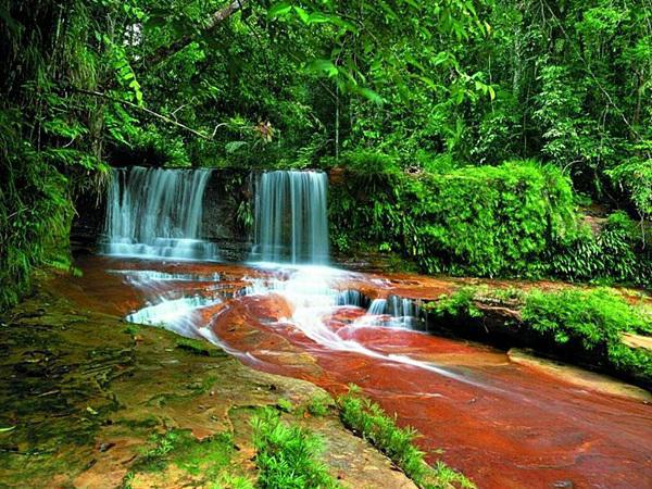
Kubah National Park covers 2,230 hectares of mixed dipterocarp forest that is rich in palms, orchids and pitcher plants. The park is dominated by the 911 metre high Mount Serapi, the mountain that provides the stunning backdrop to sunsets over the Kuching Waterfront. The forest at Kubah is mixed dipterocarp, with small areas of scrub forest and isolated patches of kerangas or heath forest. Located just 20 km from Kuching, Kubah National Park is a good day trip destination. There is also a range of accommodation at the park HQ for those interested in an overnight stay. The park’s rainforest scenery is superb and it has a rich variety of orchids and ferns. It is also famed for its rich diversity of palms, with 93 species found in the park. The park’s jungle streams and waterfalls offer great resting places to cool down after a jungle trek.
-
Jungle Trails
A series of trekking trails allows visitors to experience the park’s attractions. The Palmetum is a short trail (30 mins, one way) devoted to Kubah’s best-known feature – its palms. The Selang Trail (45 mins, one way) ends at a viewing point on Bukit Selang, one of the many hills in the park. The Belian Trail (45 mins, one way) as the name suggests passes a number of Belian or Ironwood trees. Belian is one of the finest hardwoods in Borneo owing to its strength and durability.
The Waterfall Trail (90 mins, one way) is one of the most popular and leads to a series of rock pools and waterfall whilst the Rayu Trail (2 hours, one way) connects Kubah to Matang Wildlife Centre.
Visitors can also walk along the Summit Road that leads to the top of Mount Serapi. It takes 5-6 hours to walk to the top and back. There is a viewing platform at the summit that offers amazing views of the rainforest, coastline and the wider Kuching area. -
Wildlife
Wildlife found at Kubah includes bearded pigs, mouse deer, monitor lizards, long-tailed macaque monkeys, squirrels and range of birdlife. Whilst visitors do occasionally see wildlife at Kubah, it is not is as good as Bako National Park for wildlife watching. Kubah is however a good bird watching destination with the paved road from the park HQ to the summit a good spot for early morning birding.
In recent years Kubah National Park has gained a reputation as a great place to go frogging. Over 60 species of frogs are found at Kubah, including one of the smallest species of frog in the world. -
Accommodation
The Forest Lodge Type 4 is RM 225 per night and can accommodate 6 people. These are large two storey houses set in the forest. Each house has two air-con bedrooms with attached bathrooms, a living room, refrigerator and kitchen. Bedroom one has 2 single beds whilst bedroom two has 2 single beds and a bunk bed.
The Forest Lodge Type 5 is RM 150 per night and can accommodate up to 10 people. Each unit has 3 rooms (fan), living room, refrigerator, kitchen, shared bathroom and toilet.
A bed in a 3-person hostel room is RM 15.
There is a also campsite with space for 8 tents. The camping fee is RM 5 per person. -
Food
There is no canteen at Kubah and no food stalls or places to eat within walking distance of the park HQ. So you will need to bring your own food and drinking water (or boil water at the park). There are cooking facilities and a BBQ area.
-
Entrance Fees
The entrance fee for foreigners is RM 20 (adult) and RM 7 (child, 7-18 years). The price for Malaysians is RM 10 (adult) and RM 3 (child, 7-18 years). Malaysians may be asked to show their IC card as proof of citizenship. Children 6 years and below are free.
-
Getting There
Kubah National Park is around 45 minutes drive from Kuching. City Link Bus K21 departs from the bus station near Saujana car park. The service is infrequent with departures every 2-3 hours. The first bus departs Kuching at 8 am. The last bus back from Kubah is around 3 pm. The bus fare is RM 4 (one way). The taxi fare from Kuching is around RM 70 (one way). A much cheaper option is to take a Grab car which is RM 25 (one way).
ADDRESS:
93050 Kuching, Sarawak, Malaysia
VISIT WEBSITE
BATANG AI NATIONAL PARK
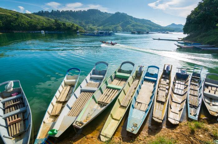
Batang Ai National Park (Malay: Taman Negara Batang Ai) is a national park located in Sri Aman Division, Sarawak, Malaysia. It is located in Lubok Antu, some 250 kilometers east of Kuching. The park covers an area of 24 square kilometres (9.3 sq mi) of extensive tropical rainforest with a number or rare and protected animals surrounding the 24 square kilometer artificial lake created by the Batang Ai hydroelectric reservoir. The park was proclaimed in 1991, and has become increasingly popular with locals and tourists despite the lack of facilities. Access is possible by chartering a boat (traditional boat called Longboat), as water is the main method of transportation in the area. The ride takes approximately about 40 minutes to Batang Ai National Park headquarters. The lush dipterocarp forests are home to the orang-utan, gibbons, and hornbills. The lake creates a beautiful environment and gives a sense of peace and tranquillity. The local inhabitants are mostly Iban, and tours to nearby Iban longhouses are also a tourist diversion. This national park takes strong steps in having the local communities involved in its management. The communities have formed a cooperative called 'Kooperasi Serbaguna Ulu Batang Ai' and are helping to conserve the park.
-
TRAILS
There are five trails in Batang Ai National Park which showcase every aspect of the park’s terrain and vegetation, such as mixed dipterocarp forest, old secondary forest and active shifting cultivations areas, with ancient burial grounds scattered around the area. Visitors must be accompanied by a registered guide or park ranger at all times.
All trails end at a pick-up point for longboat transport back to Park HQ. -
GETTING THERE
Batang Ai National Park is at the headwaters of the Batang Ai and Lubang Baya rivers, some 15km upriver from the Batang Ai Hydro Lake. Access is by motorized traditional longboat from the Aiman Batang Ai Resort jetty or the Batang Ai public jetty. There is no public longboat service and transport should be arranged in advance. The boat journey is roughly 2 hours – 1 hour crossing they hydro lake and another hour ascending the fast-flowing Batang Ai river. At times of low water visitors may have to jump into the crystal clear stream and help to push the boat through small rapids – all part of the fascinating Batang Ai experience. The Batang Ai hydro lake is about 275km (or 5 hours drive) from Kuching. Most visitors arrive as part of an organised tour group where all transport is included. Contact the Visitor’s Information Centre in Kuching for a list of approved tour operators.
-
ACCOMODATION
There is NO visitor accommodation at Batang Ai National Park. Visitors usually stay in one of the nearby Iban longhouses, or at the Aiman Batang Ai Resort and Retreat, which is roughly 1 hour 30 mins by boat from the Park HQ. The park has no canteen facilities, and visitors should bring enough food and drinking water with them. A permit is required for professional photography or filming, which should be arranged in advance with the National Park Booking Office.
-
Park Opening Hours:
8.00am to 5.00pm
Monday – Sunday including Public Holidays
ADDRESS:
Lubok Antu, Sarawak, Malaysia
VISIT WEBSITE
KUCHING WATERFRONT
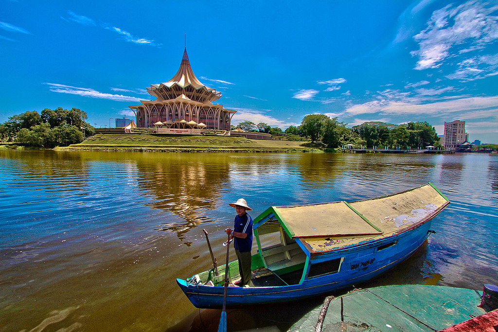
The Kuching Waterfront, is the most popular gathering place in this capital city. The esplanade stretches for about 900 meter along the south bank of the Sarawak river. Dotted the length of it are food stalls, a restaurant, bistro and street food hawkers. Many colonial-era buildings seen here have since been re-purposed for modern use. They are the Chinese History Museum, Sarawak Steamship Building and Square Tower. Besides the old, there is a modern amphitheatre that showcases scheduled live entertainment. During the daytime, the Waterfront offers excellent view of the north bank of the river. The Astana (governor’s mansion) and Fort Margherita stand out with their white exterior. The imposing State Assembly Building dominates the skyline. In addition, the Malay kampungs bring up a piece of Sarawak’s heritage that dates back to the rule of the Brooke family. At night, the whole stretch of the esplanade comes alive. Buskers fill the air with ethnic and contemporary songs and music. To add to the vibrancy, the Darul Hana Musical fountain* comes on with its colourful display.
-
Darul Hana Bridge
And immediately next to this fountain, spans the Darul Hana Bridge. This S-shaped pedestrian suspension bridge opened to the public in November, 2017. The two viewing decks offer excellent 360- panaromic view of the Sarawak River. Up here, one can’t miss the Middle Eastern-inspired Floating Mosque. The mosque is a new landmark of the Kuching Waterfront. To top it all, the sunset experience is mesmerising! Persons on wheel chair will find the walkway to the bridge proper user-friendly. *Two shows from Mondays to Thursdays at 8.30pm-8.45pm and 9.30pm-9.45pm. There are three shows from Fridays to Sundays at 8.30pm-8.45pm, 9.30pm-9.45pm and 10.30pm-10.45pm. Shows may be limited during the Muslim fasting month so do check the timing once you are here.
-
Walking Tour of Kuching Waterfront
he bridge enables one to do a circular walking tour of the north bank and the Waterfront. As a result, you can cross the river either via the bridge first or in one of the charming water taxis and then do a loop back to your starting point. Locals call the water taxis ‘Penambang‘. On this side of the river, you can visit the Brooke Gallery at Fort Margherita. For orchid lovers, the DBKU Orchid Garden has a significant collection of hybrids. As the walk may be long for some, the food court offers a welcome respite whilst enjoying vista of Kuching Vista in it’s entirety. Foodies will want to make a beeline to a kek lapis (layered cake) shop found here. The cake is a Sarawak’s signature food item. Your friends and loved ones may find this gift item…tasteful! Alternatively, buy a loaf or two to serve as energy food when you hit the trails of one of our many national parks.
ADDRESS:
37, Jalan Main Bazaar, 93000 Kuching, Sarawak, Malaysia
TRIP ADVISOR RATING
FACEBOOK PAGE
TUSAN CLIFF
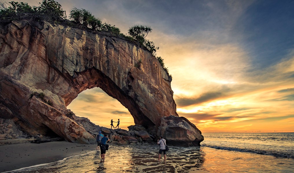
It’s a sad as the iconic rock formation of Tusan Beach is reported to have collapsed.
Tusan Beach is a well-known tourist attraction roughly 30 minutes away from Miri, Sarawak. The cliffs in Tanjung Layang-Layang arches into the sea like a horse drinking water. Hence it was fondly dubbed the “Horse Head Drinking Water”.But The beach is also famous for its ‘Blue Tears’, a natural phenomenon in which bio luminescent plankton glow in brilliant blue. It was only in 2015 that the first sighting of the ‘Blue Tears’ and the ‘Horse Head’ were discovered and propelled Tusan Beach to fame.
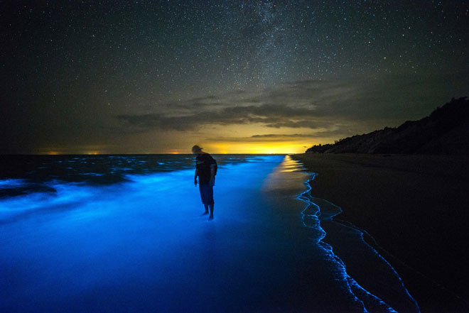
There is a great view of the open sea, and the sunsets here are phenomenal. Many come here for photography sessions.
According to the Borneo Post, the incident happened on Thursday after a heavy rain.
“22.2.2020 is a very sad day for Miri, one of the jewels of Miri’s tourist attractions is gone, the ‘horse drinking water’ feature at Tusan Beach was reported to have collapsed,” said Sarawak Minister of Transport Datuk Lee Kim Shin.
Authorities are investigating the cause of the incident.
VISIT WEBSITE
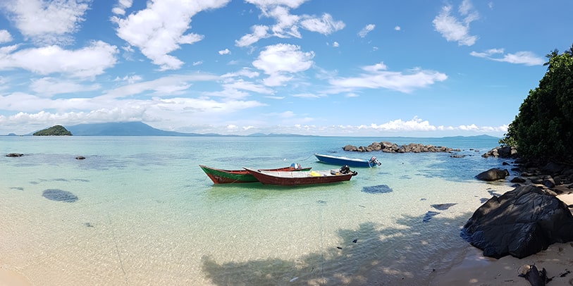
PULAU TALANG TALANG BESAR
The Talang Satang National Park is a national park in Kuching Division, Sarawak, Malaysia. It is Sarawak's first marine protected area, and covers the four islands Pulau Talang-Talang Besar, Pulau Talang-Talang Kecil, Pulau Satang Besar and Pulau Satang Kecil and surrounding coral reefs.
The park was established to protect marine turtles; four species of marine turtles are known to nest in the park, including green turtles and hawksbill turtles.
Owing to their small size and fragile environment, the Talang Talang Islands have not been developed for tourism. Instead the government’s emphasis has been on turtle conservation.Sarawak is a pioneer of turtle conservation with Talang Talang being the first site in the world to be the focus of turtle research and management activities. The now common turtle conservation strategies of tagging adult turtles and relocating eggs to hatcheries were first tried out on the tiny islands of Talang Talang.Conservation work continues today. Park rangers monitor the beaches, record turtle landings, nests, number of eggs and hatchlings. There are turtle hatcheries on both of the islands. The largest hatchery is on Pulau Talang Besar.
Whilst turtles land on the island’s beaches throughout the year, the main turtle nesting season is from April to October. June, July and August are the busiest months with 10-20 turtle landings per night. 2,000-2,500 nests and 150,000-200,000 eggs are recorded on Pulau Talang Besar each year. On average 65% of eggs hatch.
-
Reservations & Enquiries
National Parks Booking Office,
Visitors Information Centre,
Jalan Tun Abang Haji Openg,
93000 Kuching Sarawak,
Tel: (+6) 082 248088 Fax: (+6) 082 248087
for online booking click the online booking button below -
Getting There
Pulau Satang Besar is a 30-minute boat ride from Damai Beach, Sarawak Boat Club Jetty or Telaga Air Jetty. There is no regular boat service and visitors should travel in an organised tour. A number of Kuching-based tour operators run day trips to the island, often in conjunction with other marine-based activities such as dolphin watching or mangrove cruises. All other areas of Talang-Satang National Park are off limits to visitors except by special arrangement, in which case transport will be organised by Sarawak Forestry.
VISIT WEBSITE
ONLINE BOOKING
For more information on the Sea Turtle Volunteer Programme, visit here